An hour later, we'd passed Béziers, gotten off on the Béziers West exit, and started off into the hills. Grapes were everywhere, which made sense: the 19th century saw the explosion of the Languedoc wine business, as a direct Béziers-to-Paris train made it possible to send gigantic quantities of not-so-hot, strong red wine to the capital in 24 hours, making wine cheaper than ever before up there. Farmers and négotiants made out like bandits until the whole thing collapsed in 1907 with the army out quelling riots in Narbonne, Béziers, and finally a huge demonstration right here in Montpellier. These towns showed evidence of this in their architecture, and had we gone off the main route, I bet we would have seen more ostentation and possibly decaying old chateaux from the boom-times. Instead, we saw some new ones, and some old ones that had been nicely fixed up. As the day progressed, it became obvious that tour buses were no strangers to this road.
We landed in Cébazan at 1:30, puzzled. E had hit Google Maps for a route to the winery -- his plan was to "buy a six-pack" of the wine we'd had at the restaurant -- and there we were, already in town, the "rue des Vins" noted on the download having failed to appear. We parked in what looked like the parking lot of the Cave Cooperative so we could ask them where it was, but it turned out to be the old CC, the new one being next door, and all shiny with steel and glass. And locks: it would be lunch for another half hour. We jumped back in the car and backtracked, finally deciding that it would be off the road leading south to Cruzy. Then we landed in Cruzy, with none of the well-marked winemakers along the way having been the ones we were looking for. We turned around and went back to the main road. I suggested that we take a turn just before downtown Cébazan to investigate the Abbey of Fontcaude, which was listed as being 11th century, but E didn't take to that, so I suggested that we just drive on to St. Chinian and find a good wine-store which could well have it.
Just out of Cébazan, it became apparent that we'd reached the top of a hill and were about to get hit with a view. And that's just what happened. We pulled over next to a monument to some Resistance fighters who'd been killed there and I hiked back up the hill a few feet to grab a shot of the valley we were about to enter.

There was also a huge sign in French, German, and English which clearly lays out the main growing areas in the vicinity and the soil types of each and how that affects the resultant product. Nothing about the history of the area at all. But who needs history when you have wine?
Of course, we didn't have wine yet, so we wound our way down into the valley, noting that there were big signs for wine-stores along the way. Yup, those tourists again. And boy, was I glad it was out of season. So all of a sudden, we found ourselves in St. Chinian, and parked in a park shaded by plane trees. It was hard to figure what to do next, but I just thought we should hike a little ways up the road we'd just come in on and look at what appeared to be a good wine store. Finding the wine we were looking for among the bottles in the window was a nice piece of luck.
It wasn't a good wine store. It was a remarkable one, the Espace Vin St. Chinian. As you can see on this page of their website, they've got 250 square meters offering heaven only knows how many wines, the vast majority of which are St. Chinian (that's them against the far wall, taking a right turn at the back wall) but with a very well-thought-out selection of other fine Languedoc wines, and the obligatory small selection of €100+ wines from Burgundy and Bordeaux. The woman who greeted us knew her stuff, and when E picked up two bottles of the wine we hadn't found over the mountain, and I grabbed two bottles of Mas de la Serrane's Clos des Immortelles, I asked her to suggest a third wine for the rest of the "six pack" (actually a "case" in France is six bottles), and she suggested a third wine, a Pétale Pourpre from the Domaine Pin des Marguerites in nearby Berlou which had the schist, red sandstone, terroir to contrast with the limestone terroir of the Les Eminades. Sold. We got outside, laid the precious cargo in the trunk of the car, and noticed how early it was: "It's so close!" E said with evident surprise. But it is: just because the landscape's so different from where we live doesn't mean it's another planet.
We walked around St. Chinian, but it's really nothing much to look at. There was a weird sculpture or something above a door

but the only building of note was city hall, which has a very well-stocked tourist info center worth checking out on it's right-hand side as you face it.

But with a glance at the map, it appeared Roquebrun and Olargues were both easy enough to get to, so we took off towards the former, going through acre after acre of vineyards bearing names we'd just seen in the wine shop, some of which I recognized from previous encounters at the table. In fact, we missed the main turnoff to Roquebrun, and took a back route that went up and down a mountain, and when we were too high for grapes to grow, it was worth remarking on. But soon enough we pulled into Roquebrun, one of those villages that hangs on a mountain.

And which actually looks like this.

What is most notable about the place is that it's also got rocks that look like buildings. This seems to be a feature of the local mountains, many of which sprout similar formations.

About half-way up to the tower, which we didn't even attempt to get near (not to mention the admission-only garden up there), there's a church, which was nice, but locked. (The garden is all about the local micro-climate, which doesn't cool off much in winter, so a xeriscape exhibition of plants thrives there for those who want to climb up the hill. For those who don't, there's the local wine, which is apparently fantastic, part of the St. Chinian appellation.)

When we got up there, we decided to head back down the hill. There was a nice view, and someone was burning off some vines by the side of the Orb River.

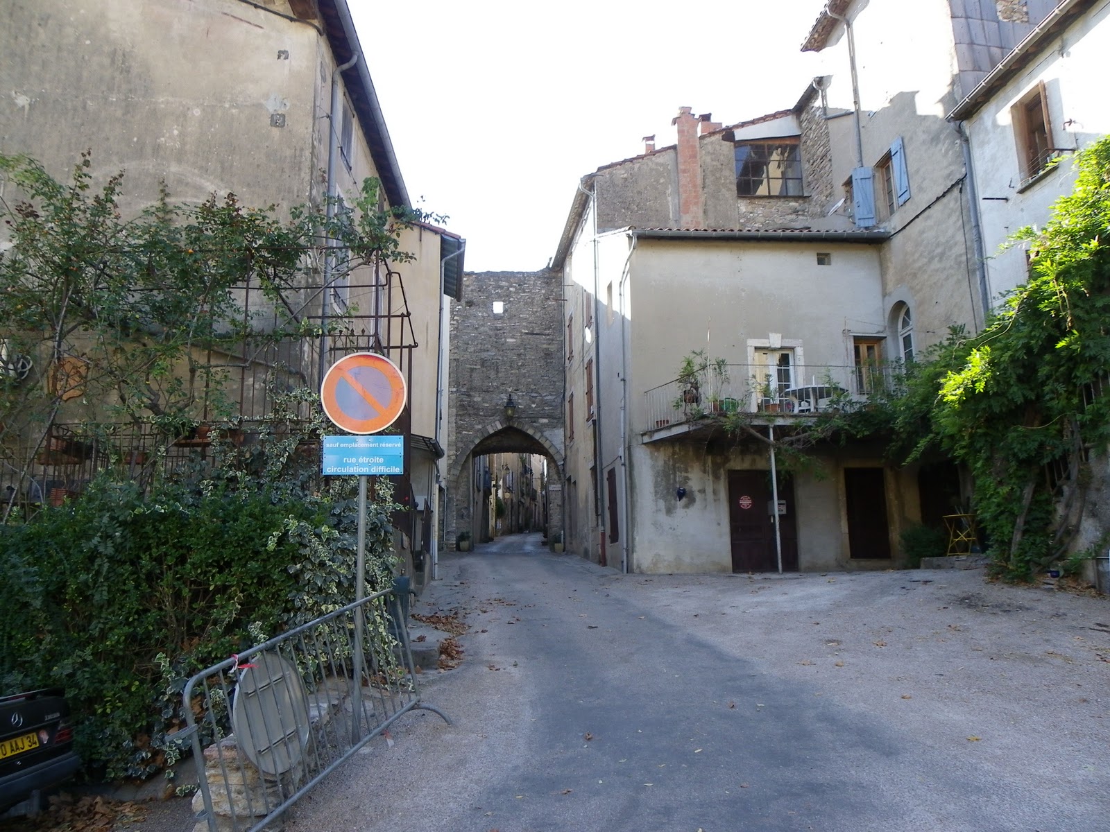
It was no problem getting to Olargues, either: it was just up the road. It was a fortified city, and much earlier we'd passed a sign on the road informing us we were in Cathar country. Roquebrun didn't have the signs of a fortified village, nor did the church appear that way. Olargues, though, might have been, but I'm not sure. The entrance to the old town is guarded by a double gate in the wall (the construction sign is modern; you'd think I'd learn how to use the damn zoom on the camera, wouldn't you?), through which a stout piece of wood could be slammed to deter invaders.
The big attraction here, too, is a tower, but a different sort than the one in Roquebrun. You reach it via an enclosed staircase which sends you up through the middle of the old village

and then you hike a bit up the hill and are confronted with this:

Which consists of this ruined bell-tower

sitting in the middle of a bunch of rubble which extends over a lot of the hilltop, which has breathtaking views of the Espinouse Mountains.

This whole area is referred to as le castrum, with castrum being a Latin word for a fortification. Nothing I've been able to find points to a Cathar connection, but I'm still not sure what the whole thing is about and the museum half-way up the covered stairway was closed, so I'll either have to go back or find a reference that makes some sense about the place. Anyway, that gated thing in the first picture is locked tight, and looking through the gate just heightens the mystery of what it is. It looks like a chapel, but has a legend on it I couldn't quite make out which seems to say it's a tomb.

That's what it looks like through the gate, anyway.
It was getting late, and we were a ways from home, so we headed back to the car and prepared to leave. Didn't happen. E has a peculiar habit of keeping the car key loose, and putting it on the seat before he sits down to drive. Which isn't a problem unless the key hits the upholstery and bounces by chance into the space between the seat and the stick shift assembly. He's a fully-qualified engineer with a doctorate and everything, and between the two of us it took us 30 minutes of pulling the driver's seat back and forth and sticking hands in where we couldn't see what we were doing and finally I spied part of the key emerging from underneath the track the seat slides on and managed to retrieve it.
The drive home started off beautiful, with all the mountains stretching into the distance, but we missed a time-saving turnoff in Bédarieux, the first of a series of seriously ugly towns we came upon, and thus climbed over a bunch of hills to Lunel and finally Lodève before we chould head down to the freeway back to Montpellier. The odometer showed we'd gone 260 km during the trip, which is a bit much, but right up until the end, when that stretch of nasty industrial towns started, it was gorgeous the whole way.
The moral? There's nothing wrong with drinking and driving, provided you do one one day, and the other the other day. The label on a bottle of wine had provided us with a fine adventure.
Oh, and the kicker: the lady at the wine shop in St. Chinian told us how to get to the Eminades winery. That road leading to the old abbey? You turn up there and there's a sign near the graveyard. Oops!
OLARGUES UPDATE: E wasn't happy with our lack of information about Olargues, and did some research the next day. It turns out that most of the original settlement was on the hilltop and it was a fortifed village whose main group of structures dated back to Romanesque times, but that in the 16th Century, Louis XIII was becoming concerned with the amount of power the individual nobles had, so he ordered all the communities like the castrum of Olargues to be razed. Even that didn't stop them, so after the Duke of Montmorency, governor of the Languedoc, proved to be too much of a pain, he was beheaded and, eventually, all the governors had to live at court in Versailles and not among the people they governed.
The other thing he researched was something I'd forgotten (probably because I didn't take a picture of it), which was there was a bright red railroad bridge running across the road into town which, a sign informed us, had been built by Gustave Eiffel. It's now part of a hiking trail, as nearly as I can figure out, but it dates from 1889. There's also another bridge which I think we would have driven into town on if we hadn't come from another direction, yet another Pont du Diable, from the 11th century or thereabouts, whose connection to Satan I can't seem to find.


Glad I could contribute in a small way to the only excursion I can recall that you didn't get lost on...well done! Did you get around to the west side of Olargues, by the way? I didn't see any photos of the medieval bridge.
ReplyDelete